Note from the Editor
by Tamara Gaskell
Window on the Collections
by Eric Klinek
Cash or Credit: Selling the Settlement of Pennsylvania
by Cathleen Miller
Philadelphia Mapmakers and the Beginnings of Commercial Mapmaking in America
by Christopher W. Lane
"Without Doubt the Most Accurate": Underground Surveying and the Development of Mining Engineering in the Pennsylvania Anthracite Region
by Eric Nystrom
Telling Neighborhood Stories through Maps
by Amy Hillier
Family Traces: Placing Our Families in the Past
by Jefferson M. Moak
Teachers' Page: Mapping South Fourth Street to Fabric Row
by Jennifer Coval
Legacies For Kids: Book Reviews
by Sarah Stippich
Map Math: Learning About Latitude and Longitude Using Coordinate Systems, by Orli Zuravicky
Map Basics, by Maxwell Baber
There's a Map on My Lap! All About Maps, by Tish Rabe; illustrated by Aristides Ruiz
Who Discovered America? by Valerie Watt; illustrated by Howie Woo
Around the World in a Hundred Years: From Henry the Navigator to Magellan, by Jean Fritz; illustrated by Anthony Bacon Venti
The Longitude Prize, by Joan Dash; illustrated by Dušan Petričić
Book and Website Reviews
by Eric Klinek
Representing the Republic: Mapping the United States, 1600–1900, by John Rennie Short
Placing History: How Maps, Spatial Data, and GIS Are Changing Historical Scholarship, by Anne Kelly Knowles
Maps: Finding Our Place in the World, by James R. Akerman and Robert W. Karrow Jr.
Geography and Vision: Seeing, Imagining and Representing the World, by Denis Cosgrove
Leg@cies: Interesting Places to Explore on the Web
Food for Thought: Good Maps, Bad Maps; or, How to Interpret A Map of Pensilvania?
by Martin Brückner
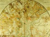
Image: John Hills, Hills Record and Historical Map or Plan of the City of Philadelphia and Environs (Philadelphia, 1808). This circular map represents a 10-mile radius around the center of Philadelphia, and, as recorded on the map, a copy of it was presented to the House of Representatives and deposited in the Library of Congress.


