Answer: Northeast Square.
William Penn’s original map for Philadelphia as a “greene Country towne” stands as one of the earliest attempts at utopian city planning and represents the most ‘pre-planned’ American city at that time. Having lived through London’s bubonic plague in 1665 and great fire of 1666, he designed Philadelphia to evade these dangers so inherent in the 17th century city. His vision arranged small country estates on a rectangular grid, each at least 800 feet from its neighbor. In his layout, Broad and High Streets intersected at a park in the center of the city and divided the rest of the city proper into four quadrants, each with a park in the center. The four equidistant parks were named according to their cardinal direction from Center Square: Northeast Square, Southeast Square, Northwest Square, and Southwest Square. They have since been renamed Franklin Square, Washington Square, Logan Circle, and Rittenhouse Square.
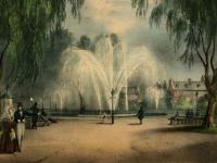
While Franklin Square may not share the same fame as its sister squares, it has an equally interesting history. In 1741, a section of the park was used by the German Reform Church as a burial ground, a decision which was retracted by the Supreme Court in 1935. Many of the congregation’s graves were relocated, however many remain on site today. During the American Revolution, Northeast Square was home to a powder house and later served as a drilling ground for troops during the War of 1812. In the 19th century, the square functioned as grazing pasture as well as a horse and cattle market. Franklin Square reopened in July 2006 after a three year, $6.5 million renovation project which restored the park’s 1838 marble fountain and added a 30-animal carousel, miniature golf course, and 2 playgrounds.
Images of Philadelphia’s four squares can be found in several of HSP’s collections, including the Society print collection (#V89), the Jane Campbell scrapbook collection (#V71), and the Philadelphia Record photograph morgue (#V7). HSP also holds maps showing the original plan of Philadelphia as laid out by William Penn.